Urban Mobility

Mapping the Invisible

Mobility landscapes in emerging cities

Poor mobility in emerging markets is a huge social issue that has been overlooked for years; it’s also one of the biggest challenges facing governments and international organisations working on sustainable urban development.

In cities where there is a reliable, affordable, inclusive public transport system for everyone, the rate and success of urban, social and economic development is higher than in cities where public transport favours a (privileged) minority. As you would expect, when a majority of the population has access to public services and new opportunities – employment, education, healthcare, recreation, etc. – they generate wealth, and the city generates wealth, and everyone thrives.

The picture is different in emerging markets – even in the fastest-growing cities. In these markets, the formal public transport systems – trains, metros, buses, Bus Rapid Transit Systems (BRTs) – mostly favour the privileged minority, while up to 80% of the population relies on informal public transport – minibus taxis, jitneys, matatus, etc. – to get around.

A typical emerging markets informal transport hub, this one is in Cape Town, South Africa

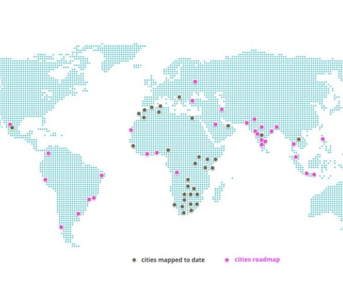
In South Africa, for example, the government has spent more than 42 billion rand (3 billion USD) in the last decade on Public Transport strategies and infrastructure in the major cities, including formal public transport infrastructure like BRT systems and rail[1]. These systems are underutilised and highly subsidised, due primarily to poor planning and implementation[2]. As a result, lower income, marginalised populations – living on the peripheries of the major cities – remain excluded. Across the country, they rely on informally run minibus taxis to get around, taking more than 50 million trips every month. Three quarters of this population has an average monthly household income below R8000 ($56), of which up to 10% is spent on transport[3]. In Cape Town, the average travel time from the periphery settlements to major economic hubs is more than an hour, over an average distance of 27 km[4]. It’s the same story around the world: low income households are spending a disproportionate amount of their income and time on public transport, and minibus taxis, jitneys, matatus, etc. remain the backbone of mobility in emerging cities.

42 billion

The South African government has spent more than 42bn rand ($3 bn) in the last decade on Public Transport strategies and infrastructure in the major cities

MAKING THE INVISIBLE VISIBLE

These informal networks can be huge; tens of thousands of vehicles operating thousands of routes every day in the largest cities.

Often when we introduce people in the developed world to the challenges of public transport in emerging markets, they assume the problem must be that there’s not enough public transport; whereas the opposite is true. But there is so little information available on the operation of these informal networks – many of which operate outside regulation – that they are effectively invisible to the city, which makes it very difficult to include them (and the 80% of the population that depends on them) in any meaningful plan for sustainable mobility. To solve a problem, you need to understand it; and to understand it, you need to be able to see it.

And this is where we start work – WhereIsMyTransport makes the invisible visible by mapping all the formal and informal modes in a city, to ensure a detailed picture of the complete network. When we have the data, we can begin analysing, drawing out the insights and the knowledge that cities and mobility service providers need to make improvements to public transport for everyone. We use our technology – or we develop new technology – to support new services; a mobile app for journey planning or a messaging app to make it easy for operators to talk to commuters, or any number of practical solutions for safer, more accessible, more affordable, more reliable, more inclusive mobility. In this way, we empower governments and mobility service providers to improve transport services for hundreds of millions of people.

Mini-bus Taxi Rank - Kampala, Uganda. Source: WhereIsMyTransport

PIONEERING MOBILITY SERVICES IN AFRICA

We began our work in Cape Town in 2015, in a small office with a group of innovative technologists, trying to solve a problem in our own city – the lack of information not only for the formal public transport modes, but also for the expansive minibus taxi network. To map the informal networks, we had to create a new suite of tools and devise new data collection methodologies; nothing available in the market was able to do the job properly. And we architected an integrated data platform with new algorithms to manage multi-modal journey planning and a host of new services – a first in Africa.

Since starting in Cape Town, we now have formal and informal public transport data for all the major cities in South Africa and beyond. In Gauteng, South Africa’s most densely populated province, we have helped the provincial government position itself as a public transport pioneer in Africa. The transport authority uses our data and our platform to provide multi-modal journey planning and other services across the province, boosting engagement with customers, to increasing ridership and reducing operating costs, and underpinning innovations like multi-modal fare integration and ticketing, which in turn create jobs and support a greener economy.

For commuters travelling to work every day, the technology we provide means a more reliable service across networks, and less time wasted in transit. For people living in revitalised settlements in Gauteng, it means access to new opportunities. For women and children, having ‘real-time’ information about public transport services means safer travel. And for the province as a whole, it means smarter cities and a more mobile population.

Out of Africa

Last year, we extended our reach beyond Africa, into Latin America, India and Southeast Asia. In December we completed our most ambitious mapping project to date: collecting the world’s most complete dataset for integrated formal and informal public transport in the Mexico City metropolitan area.

In Nagpur and Ho Chi Minh City, we hosted hackathon events, as part of our global Advocacy & Education programme, to ‘celebrate’ the mobility data. Our hackathons attract software developers, urban planners, data scientists, transport engineers, policy makers, and more. They join us for three days and, using our data and technology, develop mobility apps and solutions to real-world problems in their cities.

WhereIsMyTransport by numbers

450000km+

of routes mapped

30

cities on 3 continents

24m+

journeys planned

MAPPING MOBILITY IN MEXICO CITY

Mexico City is the largest metropolitan area in the western hemisphere, with a population of 21 million. Public transport in the metro area includes the formal modes – buses, Metrobús and the Metro – and informal microbuses called ‘Peseros’.

In 2016, the Mexican government, in partnership with ITDP, Krieger, alley, Transconsult, Urban Launchpad and Embajada Británica en México, organised a crowdsourced mapping initiative called Mapatón. Citizens were rewarded, through a gamified mobile app, for mapping Pesero routes. The product of this exercise: a first picture of the informal public transport network in the city centre.[5]

Last year, the Inter-American Development Bank (IDB) approached us with a much bigger challenge: collect data on all formal and informal modes of public transport across the metro area, including the city centre, but extending far beyond the scope of the Mapatón project.

With a complete and detailed picture of public transport – including data on routes, stops, fares, travel times, frequencies, boarding and alighting, and more – the International Transport Forum (ITF), an organisation of the OECD, will produce a report on how existing networks help the population get to work.


LOCAL PARTNERSHIP

We began in Mexico, as we do in every market, by finding a local partner. In Mexico, we were lucky to have Humberto Fuentes on the team. Humberto was one of the leaders of the Mapatón project, and he brought a tonne of experience and lessons learned from the 2016 exercise.

Sam Mehenni, our lead data collection specialist, travelled from Cape Town to work with Humberto, recruiting and training a local team of 35 data collectors, and setting up three ‘base stations’ – central, north, and south – from which they would run operations across the metro area.

DATA COLLECTION DAYS

When the teams have successfully completed a series of practice runs, we begin mapping. Data collectors ride their allocated Pesero routes several times – on different days, and during different periods of the day – capturing data using a mobile app that we designed specifically for informal public transport in emerging markets. The data collector does most of the contextual work, inputting information manually – stop names, route names, fares, boarding and alighting numbers, etc. – and the device fills in the gaps – GPS coordinates, travel times and speeds, etc. We also have collectors stationed at key hubs and stops to measure frequency.

Our local team validates the data every day; good routes are submitted for processing, and incomplete routes go back in the batch for the following day.

Validated data are cleaned and processed daily. For Mexico City, we used a team in Cape Town, working around the clock. We process data every day – rather than in bulk, at the end of the project – so that if a validated route doesn’t pass muster with the processing team, we can send it back to be remapped the following day. This is how we know we’re coming home at the end of the project with 100% ‘good’ data.

Over a period of three weeks, our team in Mexico City mapped 1,082 Pesero routes – more than 28,000 km. Now that we have integrated the Pesero routes with the data we have on formal modes, it all adds up to the world’s most complete dataset for formal and informal public transport in the Mexico City metro area.

The IDB will release its report later this year.

In the meantime, our team of data scientists and analysts are also studying this data – along with data we have collected from more than 30 cities around the world.

Using the journey planning ‘intelligence’ in our platform, and new tools and methods that we’re developing in-house, our team translates this data into knowledge and insight for a growing base of clients and influential organisations; all working with us towards sustainable mobility in emerging markets.

Collection teams meet for a daily check-in before starting collection. Source: WhereIsMyTransport

Where Next?

In January 2019, we kicked off a project more ambitious than Mexico City – roughly twice the scale – and in the first three months of the year we’ll be mapping new cities in Africa, the Balkans, the South Pacific, Latin America, and India.

For the rest of the year, we’ll be broadening our focus in Africa, continuing to look for the accelerated traction we’re seeing in other high-value markets, and continuing our expansion into new markets, with a focus on the Middle East, Latin America, India, and Southeast Asia.

Pesero in Mexico City, Mexico. Source: WhereIsMyTransport

[1]https://www.citylab.com/transportation/2013/03/limits-bus-rapid-transit-cape-town-case-study/4968/

[2] Ibid.

[3] South African National Household Travel Survey, 2013.

[4] WhereIsMyTransport GTFS, 2018

[5] https://www.oecd.org/gov/innovative-government/embracing-innovation-in-government-mexico.pdf